Johannes Blaeu, a Dutchman believed to be born in Alkmaar,
was the eldest son of Willem Janzoon Blaeu. Willem had
originally founded a business in Amsterdam in 1599 making
globes, scientific instruments and printing. Once established,
the family business quickly expanded into publishing maps.
Moreover, its prolific output was such that it became one of
the largest publishing firms in Europe during the 17th
Century. In 1620 Johannes, although becoming a Doctor of
Law, elected to go into partnership with his father. On
Willem’s death, in 1638, Johannes and his brother Cornelius
took over the business while in the same year Johannes was
appointed official cartographer to the Dutch East India
Company. However, in 1642 Cornelius died leaving Johannes
to carry on their work. In 1645 Johannes published a county
Atlas of England and Wales. This was Volume IV, of six
volumes, of the Latin edition of his ‘Theatrum Orbis Terrarum sive Atlas Novus’. Volume V, Scotland and Ireland,
was added in 1654. The whole series was completed by 1658 and contained 403 maps.
Volume IV of the Atlas Novus comprised fifty-eight plates which consisted of four general maps and fifty-five
maps of the counties and islands of England and Wales. The reverse of the maps of successive editions had text in
Dutch, French, German and Latin. Fifty-three of the total were based on Speed’s ‘Theatre’ maps with six others,
believed to be, based on his Dutch rival Jan Jansson who he had out manoeuvred by publishing his work one year
before the latter’s publication. This was a shrewd move because although Jansson had completed some of his
works much earlier than Blaeu they did not include all the counties.
On completion of the Novus he immediately undertook to transform it into a larger work. The full title was:
the ‘Atlas Maior sive Cosmographia Blaviana, qua solum, salum, coelum, accuratissime, describuntur’ (Large Atlas
or Blaeu’s Cosmography, in which the Land, the Sea and the Heavens Are Very Accurately Described). This was a
tremendous work and subsequently appeared in nine (Dutch) volumes (600 maps), ten (Spanish uncompleted)
volumes (545 maps), eleven (Latin) volumes (594 maps) and finally twelve (French) volumes (597 maps). With 600
double paged maps in the Dutch edition, it had 200 more than the Novus, it also had over 3,000 words of text. In
all editions, except the Dutch, Volume V consisted solely of England and Wales while Volume VI consisted of
Scotland and Ireland. The Atlas Maior was initially published in 1662. Ten years later, in 1672, disaster struck
when fire destroyed Blaeu’s printing works at Gravenstraat. Most of the equipment, copper plates, metal for type
and maps were destroyed. His other printing house at Bloemgracht, which printed mainly books, continued to
function, but the overall loss for the business must have been considerable. The surviving plates and map stock
were sold off and Blaeu died a year later in 1673. One of his sons, Joan, took over the business and continued to
publish maps and other work. However, it seems that the firm was now in decline. It finally closed in 1695.
Blaeu’s atlases were sold in many countries and editions were published in Dutch, French, German Latin and
Spanish. The text on the reverse of the maps, by Camden from his Britannia, was in the same language as the
publication. However, some impressions were issued without text and sold separately or in atlases. The
cartographic quality of his maps is difficult to surpass and Rutland is, arguably, by far the best work of the 17th
Century maps of the county. Not only were his atlases regularly hand coloured to a very high standard but some
were even highlighted in gold. Indeed, from Blaeu’s own price list of 1670 it showed that the Atlas Maior was the
most expensive ‘book’ then on the market.
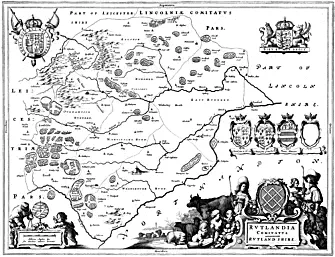
Rutland has a splendid cartouche around the title which shows a rural scene with countryfolk (probably
shepherdesses shepherd or cowherd), sheep, cattle and cherubs with fruit and vegetables. Another cartouche
surounds the scale in English miles which also indicates the equivalent in German miles. It is set under an
astrolabe and supported by a cherub and a craftsman holding a set of dividers. The Arms of King Charles I is
displayed at the top of the map. Three different coats of Arms of nobility, all copied from Speed, with one extra
blank shield completes the picture.
The Rutland map measures a total of 24
5
/
8inches (626mm) across with a top to bottom measurement of 20inches
(509mm). From the edges of the printed borders it measures 195
/
8 inches (498mm) and
151
/
8 inches (384mm) respectively.

Langham Village History Group ~ © 1996 - 2025


Johannes (Joan) Blaeu 1596 - 1673 by Anthony Wright

Johannes Blaeu, a Dutchman believed to be born in Alkmaar,
was the eldest son of Willem Janzoon Blaeu. Willem had
originally founded a business in Amsterdam in 1599 making
globes, scientific instruments and printing. Once established,
the family business quickly expanded into publishing maps.
Moreover, its prolific output was such that it became one of
the largest publishing firms in Europe during the 17th
Century. In 1620 Johannes, although becoming a Doctor of
Law, elected to go into partnership with his father. On
Willem’s death, in 1638, Johannes and his brother Cornelius
took over the business while in the same year Johannes was
appointed official cartographer to the Dutch East India
Company. However, in 1642 Cornelius died leaving Johannes
to carry on their work. In 1645 Johannes published a county
Atlas of England and Wales. This was Volume IV, of six
volumes, of the Latin edition of his ‘Theatrum Orbis Terrarum sive Atlas Novus’. Volume V, Scotland and Ireland,
was added in 1654. The whole series was completed by 1658 and contained 403 maps.
Volume IV of the Atlas Novus comprised fifty-eight plates which consisted of four general maps and fifty-five
maps of the counties and islands of England and Wales. The reverse of the maps of successive editions had text in
Dutch, French, German and Latin. Fifty-three of the total were based on Speed’s ‘Theatre’ maps with six others,
believed to be, based on his Dutch rival Jan Jansson who he had out manoeuvred by publishing his work one year
before the latter’s publication. This was a shrewd move because although Jansson had completed some of his
works much earlier than Blaeu they did not include all the counties.
On completion of the Novus he immediately undertook to transform it into a larger work. The full title was:
the ‘Atlas Maior sive Cosmographia Blaviana, qua solum, salum, coelum, accuratissime, describuntur’ (Large Atlas
or Blaeu’s Cosmography, in which the Land, the Sea and the Heavens Are Very Accurately Described). This was a
tremendous work and subsequently appeared in nine (Dutch) volumes (600 maps), ten (Spanish uncompleted)
volumes (545 maps), eleven (Latin) volumes (594 maps) and finally twelve (French) volumes (597 maps). With 600
double paged maps in the Dutch edition, it had 200 more than the Novus, it also had over 3,000 words of text. In
all editions, except the Dutch, Volume V consisted solely of England and Wales while Volume VI consisted of
Scotland and Ireland. The Atlas Maior was initially published in 1662. Ten years later, in 1672, disaster struck
when fire destroyed Blaeu’s printing works at Gravenstraat. Most of the equipment, copper plates, metal for type
and maps were destroyed. His other printing house at Bloemgracht, which printed mainly books, continued to
function, but the overall loss for the business must have been considerable. The surviving plates and map stock
were sold off and Blaeu died a year later in 1673. One of his sons, Joan, took over the business and continued to
publish maps and other work. However, it seems that the firm was now in decline. It finally closed in 1695.
Blaeu’s atlases were sold in many countries and editions were published in Dutch, French, German Latin and
Spanish. The text on the reverse of the maps, by Camden from his Britannia, was in the same language as the
publication. However, some impressions were issued without text and sold separately or in atlases. The
cartographic quality of his maps is difficult to surpass and Rutland is, arguably, by far the best work of the 17th
Century maps of the county. Not only were his atlases regularly hand coloured to a very high standard but some
were even highlighted in gold. Indeed, from Blaeu’s own price list of 1670 it showed that the Atlas Maior was the
most expensive ‘book’ then on the market.
Rutland has a splendid cartouche around the title which shows a rural scene with countryfolk (probably
shepherdesses shepherd or cowherd), sheep, cattle and cherubs with fruit and vegetables. Another cartouche
surounds the scale in English miles which also indicates the equivalent in German miles. It is set under an
astrolabe and supported by a cherub and a craftsman holding a set of dividers. The Arms of King Charles I is
displayed at the top of the map. Three different coats of Arms of nobility, all copied from Speed, with one extra
blank shield completes the picture.
The Rutland map measures a total of 24
5
/
8inches (626mm) across with a top to bottom measurement of 20inches
(509mm). From the edges of the printed borders it measures 195
/
8 inches (498mm) and
151
/
8 inches (384mm) respectively.

Langham Village History Group ~ © 1996 - 2025


Johannes (Joan) Blaeu 1596 - 1673 by Anthony Wright