John Speed was born in Farndon, Cheshire, the son of a
tailor, and continued in the trade until the age of fifty.
He became a Freeman of the Merchant Taylors’ Company
and lived in Moorfields, London, where he and his wife
raised twelve sons and six daughters. He was an enthusiastic
amateur historian and mapmaker and found that he was
able to leave tailoring and pursue his real interests in
earnest when, as a Fellow of the College of Antiquaries,
he gained the patronage of Sir Fulke Greville (Lord Brooke)
who, as adviser to the Queen and with her help, secured
him an office in the Custom House and subsidised his
map-making.
He started making County maps individually between
1596 and 1610. The maps were first sold as separate
sheets without text on their backs.
However, in 1610 Speed published a volume entitled
‘The History of England’. To accompany this he also published a topographical section. This too was in a single
volume that was divided into four Books. This volume, the Atlas, was entitled
‘The Theatre of the Empire of Great Britaine: Presenting An Exact Geography of the Kingdomes of England,
Scotland, Ireland, and the Isles adioyning: With the Shires,Hundreds, Cities and Shire-townes, within ye
Kingdome of England, divided and described By John Speed. Imprinted at London Anno Cum Privilegio 1611 and
are to be sold by John Sudbury & George Humble in Popes-head alley at ye signe of ye white horse.’
The Theatre’s Four Books were namely: England, Scotland, Wales and Ireland all of which contained sixty-seven
maps. They were engraved by Jodocus Hondius the Elder in Amsterdam and printed in London by William Hall
and John Beale.
Plagiarism among the map-making trade was commonplace and Speed was honest enough to admit that he was
no exception. Indeed he even stated “I put my sickle into other mens corne”. While he copied much of his
material from other cartographers, mainly Saxton and Norden, he did, in many cases, acknowledge the fact on
his maps. He pointedly used key words such as: ‘augmented’ and ‘performed’. However, amending the maps
with up to date information, including parish hundreds and the innovation of insetting County town plans and
other important towns within the County maps was entirely his work. He claimed to have surveyed the towns
personally and used a scale of ‘pases’ as measurement. Eventually it was through such efforts that he was able
to produce the earliest published atlas of the British Isles.
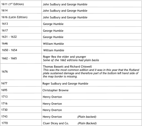
Although some maps were plain backed the majority had text on the reverse. When there was text these two
pages in the Atlas were numbered. Rutland’s text was on pages fifty-nine and sixty. The first page (reverse half
of the map) described various aspects of each County, based on earlier researches of Camden, while the other
half produced a table. In the case of the Rutland map the table was entitled ‘An Alphabeticall Table of all the
Townes, Rivers, and Places mentioned in Rutlandshire’.
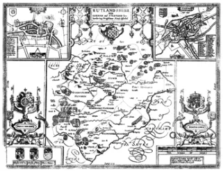
Rutland was unique in the ‘Theatre’ as it was based not on a surveyor’s work but that of an amateur, and
resident of the County, the 1st Lord Harington of Exton. The attention to detail and the minutiae depicted on
the map clearly reflects local knowledge. So too, help with Speed’s text on the reverse of the map was also
due to information imparted by Lord Harington.
Apart from one other map in the
Atlas, Rutland, because of its small
area, had the largest scale namely 6
miles to 5¼ inches. The County
town of Oakham is featured along
with, surprisingly, Stamford its near
neighbour across the border in
Lincolnshire. The Rutland map
measures, across the two pages,
21½ inches with a top to bottom
measurement of 16½ inches.
From the edges of the printed
borders it measures just less than
20¼ inches and 15¼ inches
respectively.
Two years before Speed died he
published, in 1627,
‘A Prospect of the Most Famous
Parts of the World’.
This along with the 1627 edition of
‘The Theatre’ became the first
World Atlas published by an
Englishman.
As a general guide only, the County map editions, with and without text,
along with their publishers are shown in the box above.


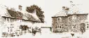
Langham Village History Group ~ © 1996 - 2025


John Speed 1552 - 1629 by Anthony Wright

John Speed was born in Farndon, Cheshire, the son of a
tailor, and continued in the trade until the age of fifty.
He became a Freeman of the Merchant Taylors’ Company
and lived in Moorfields, London, where he and his wife
raised twelve sons and six daughters. He was an enthusiastic
amateur historian and mapmaker and found that he was
able to leave tailoring and pursue his real interests in
earnest when, as a Fellow of the College of Antiquaries,
he gained the patronage of Sir Fulke Greville (Lord Brooke)
who, as adviser to the Queen and with her help, secured
him an office in the Custom House and subsidised his
map-making.
He started making County maps individually between
1596 and 1610. The maps were first sold as separate
sheets without text on their backs.
However, in 1610 Speed published a volume entitled
‘The History of England’. To accompany this he also published a topographical section. This too was in a single
volume that was divided into four Books. This volume, the Atlas, was entitled
‘The Theatre of the Empire of Great Britaine: Presenting An Exact Geography of the Kingdomes of England,
Scotland, Ireland, and the Isles adioyning: With the Shires,Hundreds, Cities and Shire-townes, within ye
Kingdome of England, divided and described By John Speed. Imprinted at London Anno Cum Privilegio 1611 and
are to be sold by John Sudbury & George Humble in Popes-head alley at ye signe of ye white horse.’
The Theatre’s Four Books were namely: England, Scotland, Wales and Ireland all of which contained sixty-seven
maps. They were engraved by Jodocus Hondius the Elder in Amsterdam and printed in London by William Hall
and John Beale.
Plagiarism among the map-making trade was commonplace and Speed was honest enough to admit that he was
no exception. Indeed he even stated “I put my sickle into other mens corne”. While he copied much of his
material from other cartographers, mainly Saxton and Norden, he did, in many cases, acknowledge the fact on
his maps. He pointedly used key words such as: ‘augmented’ and ‘performed’. However, amending the maps
with up to date information, including parish hundreds and the innovation of insetting County town plans and
other important towns within the County maps was entirely his work. He claimed to have surveyed the towns
personally and used a scale of ‘pases’ as measurement. Eventually it was through such efforts that he was able
to produce the earliest published atlas of the British Isles.
Although some maps were plain backed the majority had text on the reverse. When there was text these two
pages in the Atlas were numbered. Rutland’s text was on pages fifty-nine and sixty. The first page (reverse half
of the map) described various aspects of each County, based on earlier researches of Camden, while the other
half produced a table. In the case of the Rutland map the table was entitled ‘An Alphabeticall Table of all the
Townes, Rivers, and Places mentioned in Rutlandshire’.
Rutland was unique in the ‘Theatre’ as it was based not on a surveyor’s work but that of an amateur, and
resident of the County, the 1st Lord Harington of Exton. The attention to detail and the minutiae depicted on
the map clearly reflects local knowledge. So too, help with Speed’s text on the reverse of the map was also
due to information imparted by Lord Harington.
As a general guide only, the County map editions, with and without text,
along with their publishers are shown in the box above.


Langham Village History Group ~ © 1996 - 2025