Pieter van den Keere was born in Ghent, the son of a
schoolmaster, who, as a refugee, fled to London in 1584 to avoid
religious persecution. His sister married the remarkable
engraver Jodocus Hondius, also a refugee, and it was through
him that Keere learnt his trade both as an engraver and
cartographer. In 1593 both Keere and Hondius returned to
settle in Amsterdam where the latter took over the
cartographer Mercator’s business.
Over the years Keere engraved numerous maps for the popular
cartographers of that time. However, he is mostly known for
his early work which included a set of miniature maps based
mainly on Saxton and which were engraved from 1599.
They included English and Welsh counties, Scottish regions and
Irish provinces. It is believed that they were issued circa
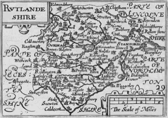
1605 – 1610 in Amsterdam with no text on the reverse. Rutland was accompanied by four other counties on the same
plate, namely: Bedfordshire, Cambridgeshire, Huntingdonshire and Northamptonshire. And as the engraving of
Rutland was so small only the places of Okeham, Uppygham, Straton, Ketton and Ticksouer, in contemporary
spelling, appeared. All other English counties had a plate to themselves. In 1617 the maps were re-issued and
published by Willem Janszoon Blaeu with Latin text on the reverse.
Eventually the plates were acquired by George Humble the publisher of Speed’s Atlas. Humble now saw another
profitable means of utilizing Speed’s name and so in 1627 he reprinted Keere’s plates again, in a pocket Atlas, to
coincide with the very popular Speed Atlas. Thus the misnomer of ‘Miniature Speed’ came into being. There were
sixty-three maps in the Atlas, arranged in the order of Speed’s Theatre and entitled: ‘England Wales Scotland and
Ireland Described and Abridged With ye Historie Relation of things worthy memory from a farr larger Voulume 1627
And are to bee sould by Georg Humble at ye Whithorse in popeshead Alley’. English text was on the reverse of each
map which described the preceding map on the opposite plate. Thus the 1627 edition showed Rutlandshire as an
individual county on plate twenty-nine. The description on the back was of Huntingdonshire which would have
appeared opposite the map of Huntingdonshire on plate twenty-eight. The Rutland description to face its own map
would be on the reverse of Leicestershire on plate thirty.
It is clear that Humble’s clever marketing of the publication ensured its popularity. Indeed it continued to be re-
issued by other important publishers such as William Humble, Roger Rea and Bassett& Chiswell until 1676.
The Rutland map measures across the page six and one sixteenth inches with a top to bottom measurement of three
and three quarter inches. From the edges of the printed borders it measures four and three quarter inches and three
and five sixteenth inches respectively.


Langham Village History Group ~ © 1996 - 2025


Pieter van den Keere 1571 - 1646 by Anthony Wright

Pieter van den Keere was born in Ghent, the son of a
schoolmaster, who, as a refugee, fled to London in 1584 to avoid
religious persecution. His sister married the remarkable
engraver Jodocus Hondius, also a refugee, and it was through
him that Keere learnt his trade both as an engraver and
cartographer. In 1593 both Keere and Hondius returned to
settle in Amsterdam where the latter took over the
cartographer Mercator’s business.
Over the years Keere engraved numerous maps for the popular
cartographers of that time. However, he is mostly known for
his early work which included a set of miniature maps based
mainly on Saxton and which were engraved from 1599.
They included English and Welsh counties, Scottish regions and
Irish provinces. It is believed that they were issued circa
1605 – 1610 in Amsterdam with no text on the reverse. Rutland was accompanied by four other counties on the same
plate, namely: Bedfordshire, Cambridgeshire, Huntingdonshire and Northamptonshire. And as the engraving of
Rutland was so small only the places of Okeham, Uppygham, Straton, Ketton and Ticksouer, in contemporary
spelling, appeared. All other English counties had a plate to themselves. In 1617 the maps were re-issued and
published by Willem Janszoon Blaeu with Latin text on the reverse.
Eventually the plates were acquired by George Humble the publisher of Speed’s Atlas. Humble now saw another
profitable means of utilizing Speed’s name and so in 1627 he reprinted Keere’s plates again, in a pocket Atlas, to
coincide with the very popular Speed Atlas. Thus the misnomer of ‘Miniature Speed’ came into being. There were
sixty-three maps in the Atlas, arranged in the order of Speed’s Theatre and entitled: ‘England Wales Scotland and
Ireland Described and Abridged With ye Historie Relation of things worthy memory from a farr larger Voulume 1627
And are to bee sould by Georg Humble at ye Whithorse in popeshead Alley’. English text was on the reverse of each
map which described the preceding map on the opposite plate. Thus the 1627 edition showed Rutlandshire as an
individual county on plate twenty-nine. The description on the back was of Huntingdonshire which would have
appeared opposite the map of Huntingdonshire on plate twenty-eight. The Rutland description to face its own map
would be on the reverse of Leicestershire on plate thirty.
It is clear that Humble’s clever marketing of the publication ensured its popularity. Indeed it continued to be re-
issued by other important publishers such as William Humble, Roger Rea and Bassett& Chiswell until 1676.
The Rutland map measures across the page six and one sixteenth inches with a top to bottom measurement of three
and three quarter inches. From the edges of the printed borders it measures four and three quarter inches and three
and five sixteenth inches respectively.


Langham Village History Group ~ © 1996 - 2025


Pieter van den Keere 1571 - 1646 by Anthony Wright